Highly prospective for Tier-1 sized iron ore copper-gold (IOCG) style mineralisation.
Hay River
The Hay River Project (Hay River) is located 400km east of Alice Springs along the Northern Territory – Queensland border. The Project is considered prospective to host IOCG style mineralisation within the prospective, but highly under explored, East Arunta Block.
Hay River was identified in 2019 during interpretation of Geoscience Australia’s AusAEM survey results, with a major conductive anomaly occurring. The anomaly measures in excess of 6km north-south, extends to depths >400m, and appears to occur beneath approximately 60m of cover.
The magnetic data for the area suggest a potential intrusive complex that appears structurally hosted. The interpreted intrusive complex is a magnetically quiet zone that possibly relates to magnetite destruction associated with hydrothermal alteration. In addition, a cluster of km scale magnetic high anomalies occur in the central portion of the interpreted complex and the strong correlation seen between magnetics and AEM data suggests this is a is a younger intrusive feature.
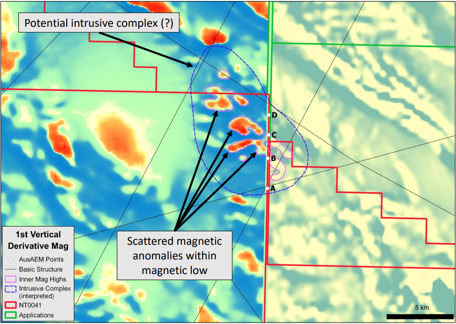
1st Vertical Derivative Magnetics (details relating to above figure)
- Zoomed in view over the Priority Target
- 1VD magnetics displays a potential intrusive complex (blue dash) that appears structually hosted
- The interpreted intrusive complex is a magnetically quiet zone that possibly relates to magnetite destruction associated with hydrothermal alteration
- A cluster of km scale magnetic high anomalies occurs in the central portion of the interpreted complex
- Strong correlation seen between magnetics and AEM between points A-D suggests this a younger intrustive feature
- Needs exploration to test
Strong coincidence between the conductive feature and large scale magnetic and gravity geophysical responses marks Hay River as a prospective conceptual IOCG target. The size and inferred geometry of this feature suggest it is an untested exploration target of true Tier 1 potential.
The Hay River Project was acquired by Inca under a joint venture and royalty agreement with MRG Resources. Inca may acquire 100% of the project, less NSR to MRG, with MRG free-carried to a decision to mine.
The Project which straddles the NT-Qld border, is held under a Northern Territory exploration licence application (EL 32579) and, following a successful Cultural Heritage Agreement negotiation with the relevant Traditional Owners, a granted Queensland Exploration Permit for Minerals (EPM 27747). The project area covers approximately 784km2 and represents Inca’s third joint venture project within the prospective East Arunta region.
Key Takeaways about this exciting new Project
")